OEM
Geodetic antenna
Designed for GNSS networks and monitoring applications

Photo: CHC Navigation
The AT661 geodetic antenna for GNSS networks or monitoring applications supports all current and future GNSS signals, including GPS, GLONASS, BeiDou, Galileo, QZSS, IRNSS, SBAS and L-band. The antenna features both high-gain LNA and wide beamwidth to provide excellent flexibility in applications requiring low-elevation satellite reception and high availability of GNSS signals, especially in obstructed situations. The accuracy of the antenna’s phase center reaches the millimeter level with extremely high stability and repeatability to ensure perfect processing of GNSS data regardless of the length of the baselines. The AT661 withstands all types of weather, including large temperature fluctuations, and is protected by a waterproof radome.
CHC Navigation, chcnav.com
Spectrum Analyzer
Portability for signal analysis

Photo: ThinkRF
The ThinkRF R5750 Real-Time Spectrum Analyzer with GPS offers high spectral performance, low power consumption, and portability. The R5750 analyzer is built for outdoor, mobile and distributed deployment scenarios, including regulatory and intelligence monitoring, telecom deployment optimization, and RF application development. Users can deploy units in a variety of network architectures, analyze signals in real-time or later, and easily integrate with leading software applications to conduct demodulation or deeper analysis of signals up to 27 GHz. The R5750 analyzer includes embedded GPS for time and location data, and comes with an optional IP66 rating for increased durability and ruggedness in difficult environments.
ThinkRF, thinkrf.com
Phase noise analyzer
For precision oscillator characterization

Photo: Microchip Technology
The 53100A Phase Noise Analyzer takes precise and accurate measurements of frequency signals, including those generated by atomic clocks and other high-performance frequency reference modules and subsystems. It combines timing technologies in a small, high-performance measurement instrument designed for engineers and scientists who rely on precise and accurate measurement of frequency signals generated for 5G networks, data centers, commercial and military aircraft systems, space vehicles, communication satellites and metrology applications. Up to three separate devices can be tested simultaneously using a single reference, enabling higher capacity for stability measurements.
Microchip Technology, microchip.com
Rugged antenna
For construction and machine control
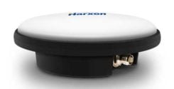
Ruggedized GNSS antenna HX-CVX600A. (Photo: Harxon)
The IP69K ruggedized HX-CVX600A antenna provides end users with millimeter accuracy, durability and productivity. The antenna is designed for applications subject to high shock and vibration environments such as machine control. Integrated with reliable signal tracking and strong anti-interference performance, the Harxon HX-CVX600A offers full support for reliable and consistent satellite signal tracking, including GPS, GLONASS, Galileo, BeiDou, QZSS, IRNSS and SBAS, as well as L-band correction services. Its stable phase center adopts multipoint feeding technology, exceptional low-elevation satellite tracking with symmetric radiation patterns, high gain with ultra-low signal loss, as well as outstanding wide-angle circular polarization. The aerodynamic enclosure withstands exposure against dust, rain, splash or sunlight.
Harxon, harxon.com
TRANSPORTATION
Marine receiver
Quad-band GNSS for marine environments
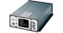
Photo: Veripos
The LD900 is a quad-band GNSS receiver capable of tracking GPS, GLONASS, BeiDou, Galileo and QZSS constellations to provide reliable and accurate positioning. The LD900 also receives L-band signals on multiple channels, providing access to Veripos’ worldwide independent correction services. Using the independent L-band RF input on the LD900 allows the connection of a dedicated L-band antenna ensuring optimal reception of correction services, especially at high latitudes. Veripos provides accurate and reliable positioning for all marine applications via their redundant positioning and multi-frequency precise point positioning (PPP) Apex and Ultra services. The Apex5 correction service utilizes all GNSS constellations delivering 5cm positioning accuracy for use in the most demanding offshore applications. Real-time kinematic (RTK) corrections can be utilized by the LD900 for applications where this service is required. The intuitive color display and navigation menu makes setup, configuration and system status monitoring simple. The display also helps troubleshoot issues with the LD900, allowing faults to be quickly diagnosed and resolved. The LD900 can also be configured remotely through the Veripos Quantum software.
Veripos, veripos.com
Tracking system
Supports internet-of-things (IoT) deployments
Photo: Particle
The edge-to-cloud IoT platform Particle is offering a new tracking system that allows organizations to track the locations of a wide variety of mobile assets. Particle’s Tracker system-on-module (SoM) provides a powerful GNSS, microcontroller and advanced peripherals in a compact form factor. Tracker SoM serves as a starting point for organizations that require a tailored tracking solution for sophisticated applications, as well as a fully certified foundation for OEMs developing commercial products. All of the company’s tracking solutions come with a high-gain GNSS antenna accurate to 1.8 meters. The field-ready solution is configurable and can track the real-time location of critical assets and capture additional intelligence via sensor data including temperature and acceleration as well as remotely controlled mobile equipment and vehicles.
Particle, particle.io
Telematics platform
Designed in Europe, now available in North America

Photo: Ruptela
The Trace 5 plug-and-play GPS-based automatic vehicle location (AVL) tracker and multifunctional fleet management platform TrustTrack provide a ready-to-use telematics solution. The Trace 5 GPS tracker has LTE Cat M1 (4G) connectivity and an integrated battery. TrustTrack is an advanced telematics platform for businesses to manage transport resources. It connects dispatchers and drivers and enables real-time monitoring and drivers’ management. It also generates trip reports.
Ruptela, ruptela.com
Vehicle Management
Uses Iridium, GPS, LTE
Photo: Blue Sky Network
The HawkEye 5500 is the a dual-mode real-time tracking and vehicle management system that supports Iridium, GPS and 2G/3G/LTE. A GNSS/Iridium antenna is included in the kit. The HawkEye 5500 offers full integration of on-board systems, support for both light and heavy-duty vehicles, two-way messaging, a remote emergency switch, collision detection, audible alerts, RFID and Bluetooth driver identification and customizable application integration. It provides global always-on coverage with high-resolution tracking and communication. Users can customize reporting rates based on movement or location and provide driver feedback when safety violations occur. All operations are tracked via Blue Sky Network’s portal, SkyRouter, which allows for effective high-security command and control of fleets anywhere on the planet.
Blue Sky Network, blueskynetwork.com
MAPPING
Mobile Mapper
For infrastructure, mining, forestry, construction
Photo: Kaarta
The Stencil Pro, now in beta testing, is a professional-grade mobile mapping platform with dimensional and visual fidelity. The all-in-one system can scan, process and view captured data in real time. It offers panoramic high-definition 4K imagery and colorized point clouds, and is optimized for both indoor and outdoor lighting. Its simultaneous localization and mapping (SLAM) capabilities enable it to operate in GNSS-denied areas such as indoor, underground, under thick canopy, or in urban canyons. However, it is also fully geo-enabled with an integrated Trimble BD-990 receiver, AV-28 antenna and a range of other third-party GNSS antennas. It supports accuracy enhancements through live RTK/NTRIP processing as well as PPK corrections. GNSS positioning data is used to align and geo-register data for accuracy. The onboard GNSS and color cameras are fully integrated into real-time capture. If a colorized point cloud is not required, or GNSS is not available, reliance on other sensors is seamless.
Kaarta, kaarta.com
Mobile app
With tool for geologists

Photo: Touch GIS
Touch GIS is a powerful mobile app for field data collection and visualization. Version 1.3 features a digital clinometer to assist field geologists in recording strike and dip readings as well as a new attitude attribute type, which makes it easy to record and display these readings on the map. Touch GIS has powerful file support for industry-standard types, offline mapping capabilities, and accurate drawing tools for points, lines and polygons.
Touch GIS, touchgis.app
UAV
Drone platform
For precise aerial inspections and data collection

The Matrice 300 RTK UAV. (Photo: DJI)
The Matrice 300 RTK is DJI’s most advanced commercial drone platform to date. It integrates modern aviation features, advanced artificial intelligence capabilities, a six-directional sensing and positioning system and a UAV health management system. It has 55 minutes of flight time. The drone platform has AES-256 encryption and an IP45 weather-resistant enclosure. A built-in all-new OcuSync Enterprise transmission system provides a triple-channel 1080p video transmission signal reaching up to 15 kilometers away. The M300 RTK can support up to three payloads simultaneously and up to a total payload capability of 2.7 kg.
DJI, dji.com
GNSS/INS Board
Robust positioning in demanding industrial environments

Photo: Septentrio
The AsteRx-i D UAS combines centimeter-level positioning with 3D orientation, enabling automated navigation of aerial drones and robots. It is compact and lightweight, with a high-performance inertial measurement unit from Analog Devices integrated directly into the receiver board. Its small form-factor combined with exceptionally low power consumption results in extended battery life and longer flight times. Both single-antenna and dual-antenna versions are available. The single-antenna version provides a lightweight solution optimizing the system size, weight and power (SWaP). The dual-antenna version is designed for machines that need reliable heading from the start.
Septentrio, shop.septentrio.com